Tropical Storm Risk (TSR)
Storm Tracker Demos: There are 4 active systems as of 13 Sep, 3:00 GMT
|
Current Data |
24-hr Ahead
Projections
|
|
13 Sep, 2004 3:00 GMT
|
14 Sep, 2004 3:00 GMT
|
|---|
| System | Basin |
| Lat | Long | Wind | Cat |
Lat | Long | Wind | Cat |
|---|
|
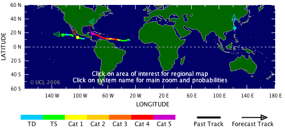
IVAN
|
N Atlantic
|
|
19.7 N
|
83.2 W
|
140 kts
|
5
|
22.3 N
|
85.0 W
|
135 kts
|
4
|
|
HAIMA
|
NW Pacific
|
|
27.1 N
|
121.7 E
|
30 kts
|
TD
|
30.0 N
|
120.5 E
|
25 kts
|
TD
|
|
ISIS
|
NE Pacific
|
|
17.4 N
|
125.1 W
|
45 kts
|
TS
|
17.4 N
|
128.4 W
|
50 kts
|
TS
|
|
JAVIER
|
NE Pacific
|
|
14.0 N
|
104.2 W
|
75 kts
|
1
|
15.7 N
|
106.1 W
|
95 kts
|
2
|
| Current Satellite Images |
|---|
| Region | Image Type |
|---|
| Atlantic |
IR | Visible |
| Atlantic |
WV | IR En |
| NE Pacific |
IR | Visible |
| NW Pacific |
IR | W Vapour |
| Indian Ocean |
IR | Visible |
| W Australia |
IR | W Vapour |
| E Australia |
IR | W Vapour |
| S Pacific |
IR | W Vapour |
|
| Tropical Cyclone Windspeed Scale |
|---|
| Strength | Category | 1 Minute Maximum Sustained Winds |
|---|
| knots | mph | km/h |
|---|
| Tropical Depression | TD | <34 | <39 | <63 |
| Tropical Storm | TS | 34-63 | 39-73 | 63-118 |
|
Hurricane
| Cat 1 | 64-82 | 74-95 | 119-153 |
|
Hurricane
| Cat 2 | 83-95 | 96-110 | 154-177 |
|
Intense Hurricane
| Cat 3 | 96-113 | 111-130 | 178-210 |
|
Intense Hurricane
| Cat 4 | 114-135 | 131-155 | 211-250 |
|
Intense Hurricane
| Cat 5 | >135 | >155 | >250 |
|

|
Researched and Developed by
Mark Saunders,
Frank Roberts
and
Adam Lea
TSR Version 4.1 Copyright © 2022
UCL University College London, UK
Last updated on 16 Feb, 2022 12:00 GMT

|

|